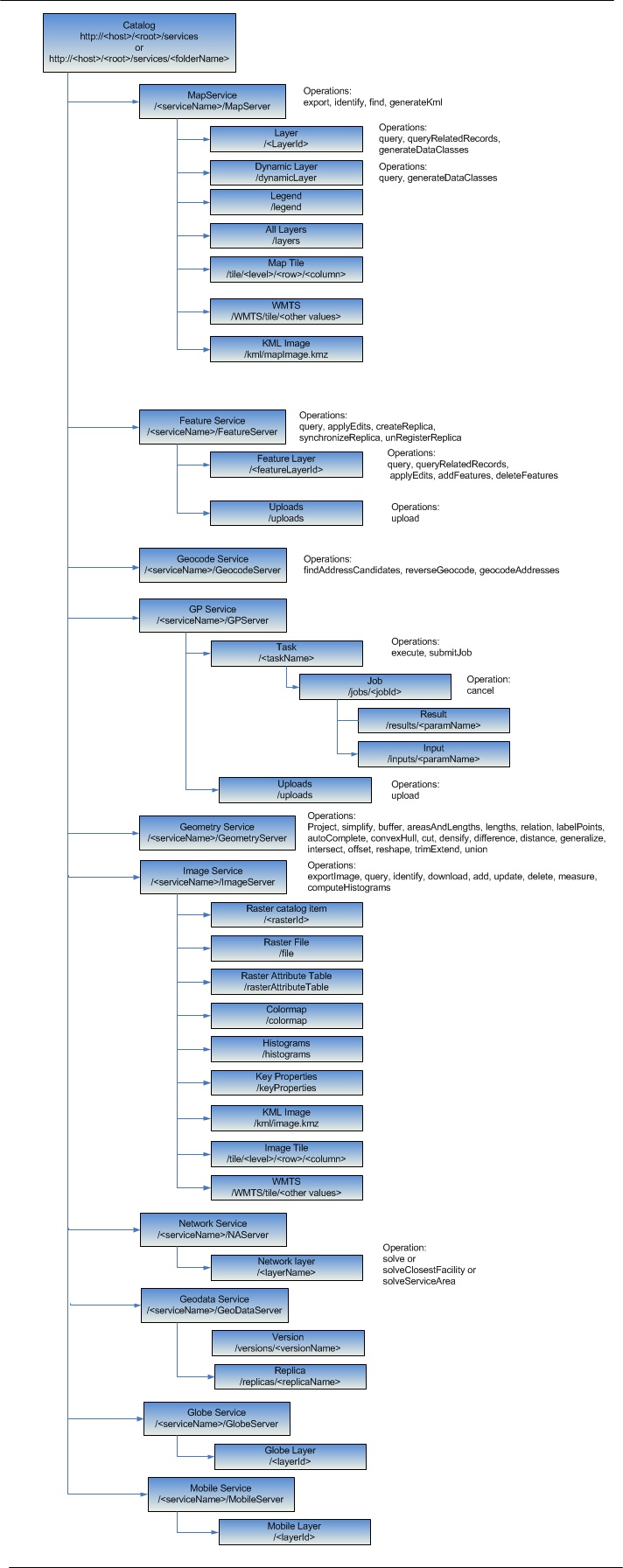
The ArcGIS REST system is a hierarchy of resources. While some resources are independent (catalog, map, layer, and so on.), other resources are produced as a result of an operation. For instance, exporting a map results in a map image resource, or querying a layer results in a result set resource. Although in both cases the client always gets back a representation of a resource, they are referred to as:
- Resources
- Operations
The hierarchy can be broken down the following way:

Catalog
The root of the URL hierarchy represents the catalog of folders and services published using ArcGIS Server. Each folder in turn also represents a catalog of services published within that folder.
Map service hierarchy
When users publish a map service and make it available through the REST API, they get access to a hierarchy of resources, such as the map service itself, map tiles, and layers. Additionally, they can execute operations on these resources, such as exporting maps and executing queries.
Feature service hierarchy
When users publish a feature service and make it available through the REST API, they get access to a hierarchy of resources, such as the features service itself and layers. Additionally, they can execute operations on these resources, such as editing and queries.
Geocode service hierarchy
When users publish a geocode service and make it available through the REST API, they get access to the geocode service resource. Additionally, they can execute operations on the geocoder, such as finding address candidates and reverse geocoding.
Geoprocessing service hierarchy
When users publish a geoprocessing service and make it available through the REST API, they get access to a hierarchy of resources, such as the geoprocessing service itself, tasks, and jobs. Additionally, they can execute operations, such as executing tasks and submitting jobs.
Geometry service hierarchy
A geometry service contains utility methods, which provide access to sophisticated and frequently used geometric operations. An ArcGIS Server web site can only expose one geometry service with the static name "Geometry".
Image service hierarchy
When users publish an image service and make it available through the REST API, they get read-only access to a mosaicked collection of images or a raster data set that make up an image service resource. Additionally, the export map operation is available.
Network service hierarchy
When users publish a map service and enable network analysis capability, the Network Layer resource and, depending on the network layer, the corresponding Route, Service Area, and Closest Facility operations will be available.
Mobile, geodata, and globe hierarchies
The mobile, geodata, and globe services running on a site are available through the REST API but have no operations associated with them.
Nota:
Globe services are deprecated at 10.5.