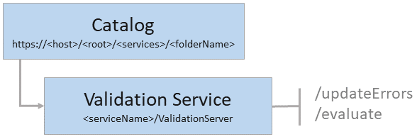
- URL:https://<catalog-url>/<serviceName>/ValidationServer
- Operations:Evaluate, Update Errors
- Version Introduced: 10.7
Description
The ValidationServer service exposes the management capabilities necessary to support evaluation of geodatabase rules. This service is available when sharing to ArcGIS Enterprise by enabling the Validation capability. To learn more, see Additional layers and capabilities.
The following rule types can be evaluated using the evaluate operation:
- Topology rules
- Batch calculation and validation attribute rules
The capabilities property is new at ArcGIS Enterprise 11.2. This property returns the capabilities that the service supports.

The validation server is tied to the published feature service as a server object extension (SOE); it shares service instance settings (for example, SOC count and time outs) with the feature service.
Learn how to configure service instance settings
Licencia:
Los miembros de la organización deben tener asignada una licencia para la extensión de tipo de usuario ArcGIS Advanced Editing para poder utilizar las siguientes operaciones del servidor de validación:JSON Response syntax
root{
"name": "Validation Server",
"type": "Map Server Extension",
"capabilities": {
"supportsTopologyValidation": <true | false>,
"supportsTopologyErrorModification": <true | false>
}
}
Example usage
Request URL: https://myserver.esri.com/server/rest/services/LandUse/validationServer
JSON response:{
"name": "Validation Server",
"type": "Map Server Extension",
"capabilities": {
"supportsTopologyValidation": true,
"supportsTopologyErrorModification": true
}
}